ONLINE EXHIBITION
17A. St. Albert's River Lots
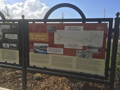
St. Albert's River Lots
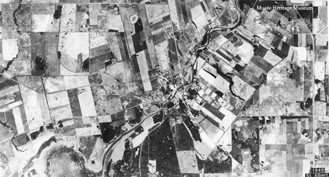
When he arrived at his new mission in April of 1861, Father Albert Lacombe, OMI, began to plan the new community. One of the first tasks was to divide up the land among the settlers. A few months earlier, he and Bishop Taché who was visiting from Manitoba, decided on an arrangement of long rectangular lots stretching back from the river. This ‘seigneurial system’ of land division was familiar to the two men. It had been established in New France (Québec) in 1627. The plan gave each landowner access to water and kept them close to their neighbours. Another advantage was that most lots had a variety of terrain, with some forest, and some land suitable for farming. It wasn’t until government surveyor W. King arrived in 1878 that the lots were recorded, and then officially surveyed by M. Deane in 1884.
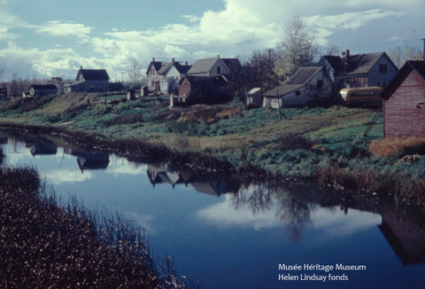
When Deane arrived in St. Albert, residents worried that the Canadian Government would eliminate their river lots in favour of the square grids of the Dominion Land Survey system. In order to save their property boundaries, the communities of St. Albert, Edmonton and Fort Saskatchewan chose Father Leduc and local farmer, Dan Maloney, to travel to Ottawa to lobby for the existing lots. The government agreed, and the river lots were preserved. During the 20th century, farming families began to sell and subdivide their lots for roads, railways and subdivisions. Today, only remnants of the original system still exist.
Dès son arrivée à sa nouvelle mission en avril 1861, le Père Lacombe, OMI, a commencé à planifier cette nouvelle communauté. Une première tâche était de diviser le terrain entre les pionniers. L’Évêque Taché, en visite du Manitoba, avait décidé avec le Père Lacombe quelques mois plus tôt de séparer les terrains en longs rectangles s’étendant de la rivière. Ce système seigneurial de diviser le terrain, établi en Nouvelle France (Québec) en 1627, était familier à ces deux hommes. Ceux-ci permettaient au propriétaire du terrain d’avoir accès à la rivière tout en gardant une proximité à ses voisins. Le système de lot riverain était aussi bénéfique, car un terrain pouvait contenir une variété de zones telles que des forêts ainsi que des terres agricoles par exemple. En 1878, l’arpenteur du gouvernement W. King, a enregistré ces lots pour la première fois et ensuite en 1884, l’arpenteur M. Deane a officialisé le tout.
Les résidents de St-Albert étaient inquiets à l’arrivée de Deane, car ils craignaient que le Gouvernement Canadien élimine leur système de lot riverain en faveur d’une méthode de quadrillage selon le système d’Arpentage des terres du Canada. Afin de retenir leurs frontières actuelles, les communautés de St-Albert, d’Edmonton et de Fort Saskatchewan, ont choisi d’envoyer le Père Leduc ainsi que Dan Maloney, un fermier local, à Ottawa pour revendiquer leur droit. Ce fut un succès, le système de lot riverain a pu être préservé. Lors du 20e siècle, les familles d’agriculteurs ont commencé à vendre et subdiviser leurs lots pour des routes, des chemins de fer et des quartiers. Aujourd’hui, nous ne pouvons retrouver que des vestiges du système original.
ispî kâkî takosinit oskihayamihêwînînâhk ayîkipîsim êkospî 1861, Father Albert Lacombe, OMI, kîmâciwiyêyihtam mâmawâyâwin. nîkân piko katâskinamât askiy askîwotinâsowina. nâway pîsimohk, wiya êkwa Bishop Taché kâkî pêkiyokâkot ohci Manitoba, kîsêyihtamwak kanahawâstâcik kinowâskîya êpêhiskwamok ohci sîpiy. ôma ‘seigneurial system’ tipêyihtamowin kiskêyihtamwak askiy êkîhotinaskêhk anita New France (Québec) îkospî 1627. oyêyihcikêwin kîmiyâwak kahkiyaw askiy otipêyihcikêwak nipiy êkwa cîki owîtaskêmâkana. pîtos kêtâpacihtâhk mîna isi kistikêwin êkwa apisis êsakâhk, êkwa kakistikêhk. namoya isko kihci okimânâhk otipahaskêw, W. King kâkîtakosinit ispî 1878 kwêyask kâkîmasinahak askîya, êkwa otipahâskêw M. Deane ispî 1884.
ispî Deane kâkîtakosinit St. Albert, ayisiyiniwak wânêyihtamwak Kanata kihci okimâwak êkâ kâpisiskêyihtamihk askîyawâwa isih kâhkatikwanâskiy tâpiskôc Dominion Land Survey êhisiyihkâtêki. kakanawêyihtâkik otaskîwâwa, mâmawi St. Albert, amiskwacîwâskahikan êkwa Fort Saskatchewan nawasônêwak Father Leduc êkwa kistikêwiyinîwiw, Dan Maloney, kêtohtêt Ottawa kapîkiskwâta kakanawêyihtamihk sîpiy askîya. kihci okimâwak tapwêhtamwak, êkwa sîpiy askîya kakanawêyihcikâtêki. ispî ôma mitâtahtomitanaw askiy, kistikêwiyinîwiwak mâci atawakêwak êkwa taskinamâtowak otaskîwâwa ohci mêskanawa, pîwâpisko mêskanawa êkwa pâpiskic wikowina. anohc, anihi êkota kâhayâki kêyâpic êkota astêwa.


